

(Click the image to view prototype 😊)
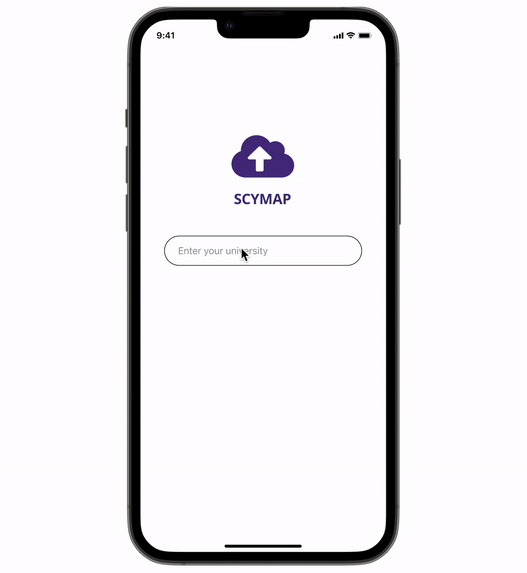
SCYMap - Smart Parking Solutions for Universities
Mobile App Design | UX Design
Project Overview
The Product
SCYMap is a mobile application that provides a smart way to find parking at universities. By simply typing in destinations, SCYMap helps drivers discover where to park near their destinations in advance. The results of parking places can be sorted by “Distance”, “Price” and “Available Spots” to maximize customized options. Most importantly, drivers are kept informed of the live data of remaining parking spots along the way to ensure that they can guarantee a spot when they arrive.
The Challenge
Where the Story Begins…
During our product design kick-off meeting, our team member Moses was late because it took him a long time to find a parking spot on campus. This led us to an existing user pain point, that it was difficult for college students to find parking spots on campus. So we started researching about the parking situation on UW campus.
The Current Way to Find Out Parking Info at the University of Washington…
After typing in “UW parking” at a search engine, you can find a map showcasing the lots & garages info at the UW Transportation Services website. The map is static and hard to view, and the entire process is time-consuming and frustrating.
“How might we design a smooth experience that provides smart parking solutions for universities?”
My Team
Spencer Li, Cindy Wu, Yolanda Jiang, Moses Wan
My Role
UX Designer & Researcher
Timeline
5 Weeks
Researching
Survey
We first conducted a user survey to understand user pain points regarding finding parking on campus.
Key Findings:
Students have trouble finding parking spots close to their destinations.
Some parking signs are confusing. (i.e., students aren’t sure if they have permission to park)
Students are worried about being late due to having trouble finding parking spots.
User Interviews
We also interviewed with 5 students at UW over Zoom, to further understand the challenges they face when finding parking on campus.
Key Findings:
The current UW Transportation Services website is frustrating to use.
Parking signs are very confusing (i.e., it’s unclear that if the parking lot is public, private, or student only, and it’s hard to know where to pay.)
Students have to park far away from their destinations and walk for long.

Persona
Based on surveys and interviews, we created a persona to represent the needs and characteristics of our target users.

API Research
Before designing, we also researched on API to understand the technology viability and constrains.
Through research, we understand that a parking API is an Application Programming Interface that programmers can use to connect applications to parking information and other data. There’re smart city initiatives where technologies such as cameras, sensors and other IoT are installed to monitor and collect data about parking spaces. The data collected are then sent to parking APIs such as SpotHero. However, it’s not feasible to develop a “Parking spot reservation” feature because there’s no way of guaranteeing a spot is still there when the user arrives.
Ideation
User Journey Map
Based on earlier research, we created a user journey that maps out each journey steps as well as actions, needs, pain points and touchpoint involved in each step.
Storyboard

I also drew a rough storyboard to visualize the online and offline experience.
The scenario is that SCYMap helps UW student James find a parking place in advance and get to his class on time.
Start Sketching
Combing the storyboard, we started brainstorming and drew paper wireframes to visualize our ideas.

Designing & Testing
Lo-fi Wireframes
Based on earlier sketches, we stared to create low-fidelity wireframes. At this stage, mapping out main frames and key features of the application were essential parts of our design strategy.
Usability Study
We conducted usability tests with four UW students who drive to campus frequently. Through the testing, we hope to understand if the current user flows easy to understand and can resolve user needs.
Main Tasks:
Walk through the onboarding process.
Enter the destination and review the parking lots displayed.
Select a parking lot around the destination, review the info tab and start navigation.
Arrive at the chosen parking lot, and review the information displayed.
Start walking navigation and arrive at the final destination.
Affinity Map:
Key Recommendations:
Add a ranked parking lot result after typing in the destination.
More complete parking signs and parking info.
Add turn by turn navigation.
Extend the business scope.
Refining Highlights
1. A smart way to find parking
A ranked parking lot result is shown after typing in the destination. When selecting a parking lot, complete parking info (pricing, permission, time limit, remaining spots, etc.) is shown for user reference.

2. Extend the business scope
Instead of focus on UW parking, we extend the business scope to allow users select a particular university and provide smart parking solutions for them.

Design Solution
Mockups
Hi-fi Prototype
The final design allows users to
Select a university in the States.
Discover available parking places in that university in advance.
Be informed of the live data of available parking spots when being navigated to the parking place.
Pay for their parking easily.
Be navigated from their parking spot to their final destination.
Going Forward
Reflections
This is the project I completed for my Advanced UX Design class. It’s an intense class as we need to complete the project within 5 weeks. And there’re still a lot we can improve to make it more complete. One thing we can do is to discover more opportunities for the app. For example, to make the experience more useful, we can allow students to import class schedules into the system and recommend parking solutions based on those data. We can also try pitching this idea to the university to further understand the feasibility and constrains of actually implementing this solution. Finally, if we have more time to invest, we should carry out a usability study to test whether it’s safe to use this app while driving.